https://www.darabanth.com/
https://static.darabanth.com/
https://static.darabanth.com/auction/img/
https://www.darabanth.com/
Continuous online auctions
Tétel

cca 1920 Magyarország térkép/Carte Géographique de La Hongrie/Map of H...

Sold

Catalogue number:

13460.
385. Closed Online auction
Maps

Starting price:

8 000 HUF

Number of bids:

1

Description:

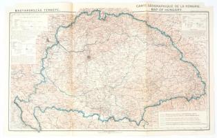
cca 1920 Magyarország térkép/Carte Géographique de La Hongrie/Map of Hungary, az alap térképet tervezte: Kogutowicz Károly, 1:500.000, Bp., Magyar Földrajzi Intézet Rt., magyar, francia és angol nyelven, az egyik felső sarkán a lap szélén kis, a térképet nem érintő hiánnyal, 43x68 cm

Share:

Facebook

Photo of the item taken by : karap_norbert

further page navigation

Contact

Opening hours

  • Monday: 12-17
  • Tuesday-Wednesday: 10-17
  • Thursday: 10-19
  • Friday: closed
  • Weekend: closed

Our sites

© 2011-2024 Darabanth Philatelic and Numismatic Auctions Co., Ltd.
We use cookies on the Darabanth website to enhance your user experience.
By using this site you agree to the placement of cookies on your computer.
I agree
For details, please click here
https://www.darabanth.com/en/feltetelek/#privacy_policy
darabanth.com
Livestream

Current item in the room
Catalogue number:
Here you can follow which item is up in the room. You can bid for the item at the item details.
Item added to the basket

Basket cost in total:

Continue shopping
  To the payment