https://www.darabanth.com/
https://static.darabanth.com/
https://static.darabanth.com/auction/img/
https://www.darabanth.com/
Continuous online auctions
Tétel

1920 Magyarország gazdaságföldrajzi térképe/Carte de géographie économ...

The item is not available

Catalogue number:

13459.
385. Closed Online auction
Maps

Starting price:

16 000 HUF
43,24 EUR, 47,06 USD

Number of bids:

0

Description:

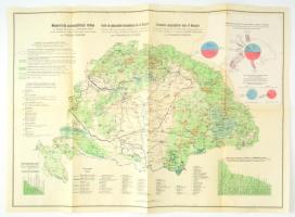
1920 Magyarország gazdaságföldrajzi térképe/Carte de géographie économique de la Hongrie/ Economic-geographical map of Hungary, 1:15,00.000. Dr. Teleki Pál gróf és dr. Cholnoky Jenő közreműködésével hivatalos adatok alapján szerkesztette: dr. Fodor Ferenc. (A felső sarkában felragasztva: Magyarország behozatali és kivételi forgalma szárazon és tengeren.) Bp., Magyar Földrajzi Intézet Rt., magyar, francia és angol nyelven, egészen apró javítással, jó állapotban, 58x78 cm

Share:

Facebook

Photo of the item taken by : karap_norbert

further page navigation

Contact

Opening hours

  • Monday: 12-17
  • Tuesday-Wednesday: 10-17
  • Thursday: 10-19
  • Friday: closed
  • Weekend: closed

Our sites

© 2011-2024 Darabanth Philatelic and Numismatic Auctions Co., Ltd.
We use cookies on the Darabanth website to enhance your user experience.
By using this site you agree to the placement of cookies on your computer.
I agree
For details, please click here
https://www.darabanth.com/en/feltetelek/#privacy_policy
darabanth.com
Livestream

Current item in the room
Catalogue number:
Here you can follow which item is up in the room. You can bid for the item at the item details.
Item added to the basket

Basket cost in total:

Continue shopping
  To the payment