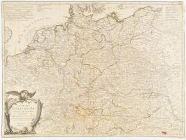
1784 L'Empire d'Allemagne Divisé par Cercles Subdivisés en leurs Etats et Souverainetés, ... par le Sr. Janvier Geographe. ? Venise par P. Santini. / Német birodalom rézmetszetű térképe. Körbevágva. Szélén hátul ragasztással megerősítve. / The German Empire divided by circles subdivided into their states and sovereignties engraved map 470x640 mm
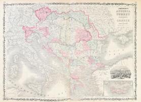
1863 Johnson Map of Austria, Turkey, and Greece. Ausztria, Magyarország, a Balkán és Törökország térképe. Színezett acélmetszet Constantinápoly látképével. / Colored map of Austria-Hungary with the image of Constantinople 67x47 cm
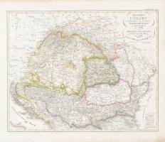
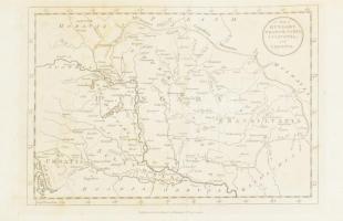
1827 Stieler, Adolf: Galizien, Ungarn mit Sclavonien und Croatien, Siebenburgen und Dalmatie - Magyarország Galicia, Szlavónia, Erdély... térképe Színezett rézmetszet Szélén kissé foltos. / 1827 Map of Hungary, Galicia, Transylvania, Croatia and Slavonia. Colored engraving 355x285 mm
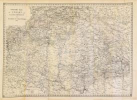
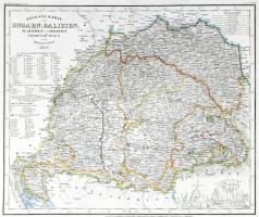
1847 Neuseste Karte von Ungarn, Galizien, ...Siebenbürgen... Magyarország ,Gallicia, Szlavónia, Horvátország és Erdély és a Határőrvidék térképe. Meyers, Etnikai csoportok megjelölésével. is. Színezett rézmetszet, / 1847 The newest map of Hungary, Galicia, Transylvania, Croatia and Slavonia. With indication of ethnical groups. Colored etching 354x290 mm
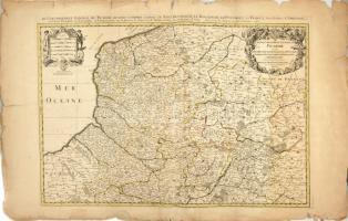
Le Gouvernement General De Picardie, ou sont le Pays Reconquis, Le Bulenois, Le Ponthieu, l'Amienois, Le Santerre, Le Vermandois et Le Tierrache. Alexis-Hubert Jaillot. 1692. Színezett rézmetszetű térkép Franciaroszág Picardia tartományáról. A lap szélén szakadásokkal. / Hand colored engraving. 800x560 mm
1784 A map of Hungary, Transilvania, Sclavonia, and Croatia. _ Magyarország, Erdély, Szlavónia és Horvátország rézmetszetű térképe. Harisson, J. London / engraved map 31x21,5 cm Hajtva
1804 Czetter Sámuel (1765-1829 k.): Somogy vármegye térképe. C[omitatus] Sümeghiensis, rajta: Huszt, Máramarossziget, Kőrösmező, In: [Korabinszky János Mátyás]: Korabinsky, Johann Matthias: Atlas Regni Hungariae Portatilis LVIII. Bécs, 1804. Schaumburg und Compagnie, színezett rézmetszet,10,5x16,5 cm.
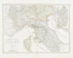
1836 C. F. Weiland: Ober und Mittel Italien - Felső és középső Olaszország térképe. Nagyméretű, acélmetszet. / Large map of Italy. Large etched map. metszet: 29x32 cm
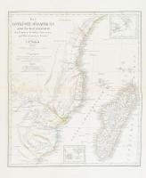
1828 C. F. Weiland: Die Ostküste Süd-Africa's nebst der Indel Madagascar - Dél-Afrikai keleti parjtjának és madagaszkár térképe. Nagyméretű, acélmetszet. / Large map of Kingdom of Africa and Madagascar. Large etched map. metszet: 35x41 cm
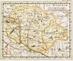
XVIII. sz. közepe La Hongrie, Magyarország térképe, Buffier, Claude: Geographie universelle, kézzel színezett rézmetszet, paszpartuban, 13x16 cm, paszpartu: 26x28 cm

![1804 Czetter Sámuel (1765-1829 k.): Somogy vármegye térképe. C[omitatus] Sümeghiensis, rajta: Huszt, Máramarossziget, Kőrösmező, In: [Korabinszky János Mátyás]: Korabinsky, Johann Matthias: Atlas Regni Hungariae Portatilis LVIII. Bécs, 1804. Schaumburg und Compagnie, színezett rézmetszet,10,5x16,5 cm.](https://static.darabanth.com/images_thumbs/2/8/2870014.jpg)