https://www.darabanth.com/
https://static.darabanth.com/
https://static.darabanth.com/auction/img/
https://www.darabanth.com/
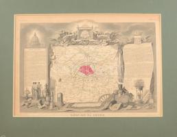
cca 1850 Départment du Seine (Franciaország) megye térképe, Atlas Nati... https://www.darabanth.com/en/online-auction/428/categories~Art-and-other-collectibles/Maps~500029/cca-1850-Department-du-Seine-Franciaorszag-megye-terkepe-Atlas-National-Illustre-42x28-cm-p~II2696451
The item is not available
2696451
13986
428
0
5000
Maps
Other collectibles
Starting price:
5 000 HUF 13,51 EUR , 14,71 USD
Description: cca 1850 Départment du Seine (Franciaország) megye térképe, Atlas National Illustre, 42x28 cm. paszpartuban/ cca 1850 Map of Départment du Garonne (France), Atlas National Illustre, 42x28 cm
Share: Facebook
Photo of the item taken by
: nagy_andras
further page navigation Contact
Address:
Mailing Address:
Phone:
Fax:
E-mail
:
icvqw34r5 nf?3+ o@dasdfefg rabanwf34 th.codv4 m
Opening hours
Monday: 12-17
Tuesday-Wednesday: 10-17
Thursday: 10-19
Friday: closed
Weekend: closed
© 2011-2024 Darabanth Philatelic and Numismatic Auctions Co., Ltd.
We use cookies on the Darabanth website to enhance your user experience.
I agree
For details, please click here
https://www.darabanth.com/en/feltetelek/#privacy_policy
darabanth.com
Item added to the basket
Continue shopping