https://www.darabanth.com/
https://static.darabanth.com/
https://static.darabanth.com/auction/img/
https://www.darabanth.com/
Continuous online auctions
Tétel

cca 1910 Az Osztrák-Magyar Monarchia hegy és vízrajzi térképe, 1:4.000...

Sold

Catalogue number:

14471.
408. Closed Online auction
Maps

Starting price:

1 000 HUF

Number of bids:

1

Description:

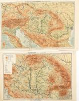
cca 1910 Az Osztrák-Magyar Monarchia hegy és vízrajzi térképe, 1:4.000.000, valamint Magyarország hegy és vízrajzi térképe, 1:2400.000, kiadja: Bp., Kugotowicz és Társa, Magyar Földrajzi Intézete, in: Kogutowicz Manó: Középiskolai földrajzi atlasz, hajtottak, az egyiken kis javításokkal, 29x48 cm és 29x45 cm

Share:

Facebook

Photo of the item taken by : pelikán_kristóf

further page navigation

Contact

Opening hours

  • Monday: 12-17
  • Tuesday-Wednesday: 10-17
  • Thursday: 10-19
  • Friday: closed
  • Weekend: closed

Our sites

© 2011-2024 Darabanth Philatelic and Numismatic Auctions Co., Ltd.
We use cookies on the Darabanth website to enhance your user experience.
By using this site you agree to the placement of cookies on your computer.
I agree
For details, please click here
https://www.darabanth.com/en/feltetelek/#privacy_policy
darabanth.com
Livestream

Item added to the basket

Basket cost in total:

Continue shopping
  To the payment