https://www.darabanth.com/
https://static.darabanth.com/
https://static.darabanth.com/auction/img/
https://www.darabanth.com/
Continuous online auctions
Tétel

cca 1844-1860 Geognostische Karte von Central- und West-Europa einschl...

Sold

Catalogue number:

14474.
408. Closed Online auction
Maps

Starting price:

5 000 HUF

Number of bids:

1

Description:

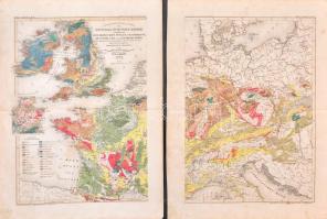
cca 1844-1860 Geognostische Karte von Central- und West-Europa einschlieslich der Britischen Inseln, Frankreich, Deutschland und der Nachbarlander. Mit Zugrundlage der Karte von Dr. H. von Dechen, Professor der Berliner Universitat, und der Werke der eminentesten europaischen Geologen, entworfen von W. Hughes, F.R.G.S. mit verbesserungen u. Berichtigungen von J. Meyer. 1844. Gez. v. Jos. Graessl. Meyer's Handatlas N. 29-30. Hildburghausen, Bibliographischen Instituts, 2 db kézzel színezett acélmetszetű térképszelvény, kis szakadásokkal, kis foltokkal, 38x28 cmx2, lapméret: 46x35 cmx2

Share:

Facebook

Photo of the item taken by : pelikán_kristóf

further page navigation

Contact

Opening hours

  • Monday: 12-17
  • Tuesday-Wednesday: 10-17
  • Thursday: 10-19
  • Friday: closed
  • Weekend: closed

Our sites

© 2011-2024 Darabanth Philatelic and Numismatic Auctions Co., Ltd.
We use cookies on the Darabanth website to enhance your user experience.
By using this site you agree to the placement of cookies on your computer.
I agree
For details, please click here
https://www.darabanth.com/en/feltetelek/#privacy_policy
darabanth.com
Livestream

Item added to the basket

Basket cost in total:

Continue shopping
  To the payment