https://www.darabanth.com/
https://static.darabanth.com/
https://static.darabanth.com/auction/img/
https://www.darabanth.com/
The item is not available
13618.
402. Closed Online auction
Maps
20 000 HUF
54,05 EUR, 58,82 USD
0
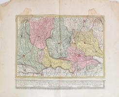
cca 1760, Mantova és a környező észak-itália területek (Velence, Milánó, Bergamo stb.) valamint a mai Svájc és Ausztria egyes részeinek térképe (Das Hertzogthum Mantova und Mirandola sampt angraentzenden Venedischen-Laendern wie auch Tyrolischen und Graubünterischen Graentzen neben einen Theil des Herzogthums Meyland waraus sonderlich die gloriose Expedition der Käyserlichen Armée in Italien). Rézmetszet, kézzel színezett, papír, hajtásnyommal, foltos, lap szélén kisebb sérülésekkel, hátul közepén megerősítve, 41,5x51 cm, lapméret: 56,5x72 cm / cca 1760 Map of Mantova and the Northern Italian (Milano, Venice), Swiss and Austrian surrounding territories. Copper engraving, hand coloured, spotty, with some damages on the edges, 41,5x51 cm
Basket cost in total: