https://www.darabanth.com/
https://static.darabanth.com/
https://static.darabanth.com/auction/img/
https://www.darabanth.com/
Continuous online auctions
Tétel

cca 1928 Magyarország és a vele határos területek földtani térképe, ös...

The item is not available

Catalogue number:

13093.
307. Closed Online auction
Maps

Starting price:

5 000 HUF
13,51 EUR, 14,71 USD

Number of bids:

0

Description:

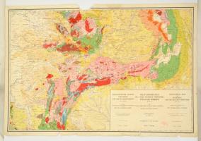
cca 1928 Magyarország és a vele határos területek földtani térképe, öszeáll: M. Kir. Földtani Intézet, 1914-es határok szerint, Bp. M. Kir. Földtani Intézet, egy lap, négy lapban teljes, szakadt, sérült, hiányos, 63x94 cm.

Share:

Facebook

Photo of the item taken by : vörös_iván

further page navigation

Contact

Opening hours

  • Monday: 12-17
  • Tuesday-Wednesday: 10-17
  • Thursday: 10-19
  • Friday: closed
  • Weekend: closed

Our sites

© 2011-2024 Darabanth Philatelic and Numismatic Auctions Co., Ltd.
We use cookies on the Darabanth website to enhance your user experience.
By using this site you agree to the placement of cookies on your computer.
I agree
For details, please click here
https://www.darabanth.com/en/feltetelek/#privacy_policy
darabanth.com
Livestream

Item added to the basket

Basket cost in total:

Continue shopping
  To the payment