https://www.darabanth.com/
https://static.darabanth.com/
https://static.darabanth.com/auction/img/
https://www.darabanth.com/
Continuous online auctions
Tétel

cca 1700 Olaszországi területek térképe. Összesen 6 db: Nápoly, Guast...

The item is not available

Catalogue number:

13019.
307. Closed Online auction
Maps

Starting price:

15 000 HUF
40,54 EUR, 44,12 USD

Number of bids:

0

Description:

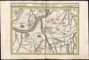
cca 1700 Olaszországi területek térképe. Összesen 6 db: Nápoly, Guastalla, Szardínia, Mantova Színezett, díszes kartusú rézmetszet. Megjelent: Johann Hofmann Atlas Curieux oder neuer und Compendieuser Atlas. (Augsburg, 1700). Méret: 29x20 cm / cca 1700 Maps of Italy. Colored etching 31x20 cm

Share:

Facebook

Photo of the item taken by : ra

further page navigation

Contact

Opening hours

  • Monday: 12-17
  • Tuesday-Wednesday: 10-17
  • Thursday: 10-19
  • Friday: closed
  • Weekend: closed

Our sites

© 2011-2024 Darabanth Philatelic and Numismatic Auctions Co., Ltd.
We use cookies on the Darabanth website to enhance your user experience.
By using this site you agree to the placement of cookies on your computer.
I agree
For details, please click here
https://www.darabanth.com/en/feltetelek/#privacy_policy
darabanth.com
Livestream

Item added to the basket

Basket cost in total:

Continue shopping
  To the payment