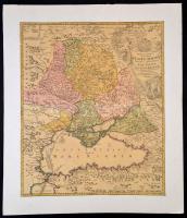
1720 Johann Baptist Homann: Oroszország és a Fekete tenger környékének térképe. Tabula Geographica qua pars Russiae Magnae Pontus Euxinus seu mare Nigrum et Tartaria Minor cum finitimis Bulgariae, et Romaniae et Natoliae... Színezett rézmetszet kartonra ragasztva. /
1720 Map of Russia and the Black Sea area. Colored etching. 49x58 cm
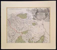
cca 1720 Johann Baptist Homann: Marchionatus Moraviae Circulus Preroviensis quem Mandato Caesareo accurate emensus hac mappa delineatum publice exhibet Színezett rézmetszet paszpartuban. /
cca 1720 Map of Moravia and neighbouring area. Colored etching in paspartu 56x47 cm
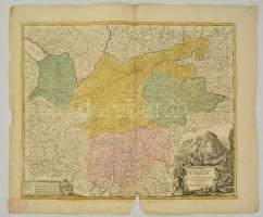
cca 1700 Tirol térképe. Comitatus principalis Tirolis in quo episc. Tridentin et Brixensis comitatus ... Homann, Johann Baptist (1663-1724). Nagyméretű színezett rézmetszetű térkép. Kis hiánnyal. / Large etched map of Tirol. Small part missing. 67x58 cm
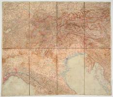
cca 1900-1910 Alpok és Észak-Itália térképe, 1:750.000, vászonra kasírozva, bejelölésekkel, a vászon hátoldala foltos, 67x79 cm./
cca 1900-1910 Map of Alps, and Northern Italy, 1:75.000, on canvas, with marks,the back of the canvas is spotty, 67x79 cm.
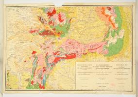
cca 1928 Magyarország és a vele határos területek földtani térképe, öszeáll: M. Kir. Földtani Intézet, 1914-es határok szerint, Bp. M. Kir. Földtani Intézet, egy lap, négy lapban teljes, szakadt, sérült, hiányos, 63x94 cm.
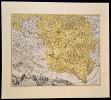
cca 1700 Csehország déli részének, és a Magyar Királyság szegletének rézmetszetes térképe. Színezett rézmetszet, vadászjelenetet ábrázoló díszes kartussal. Paszpartuban / cca 1700 South of Czech Republic, colored etching. In paspartu 58x47 cm
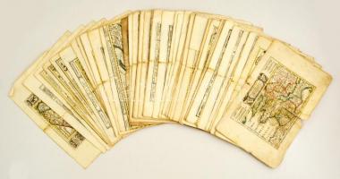
cca 1690-1700 57 darab térkép. Európai országok részek színezett, díszes kartusú rézmetszetei. Megjelent: Johann Hofmann Atlas Curieux oder neuer und Compendieuser Atlas. (Augsburg, 1700). Méret: 29x20 cm 90 % ban szép állapotban. / cca 1700 57 maps. Colored etchings. German parts, France, Netherlands, Italy, Mediterranians 31x20 cm
Alte Karten im Lichtdruck. Fünf Karten Libyens und Sambias. Folge 11. Edition Leipzig, 1976. 1 térkép hiányzik. Kiadói hengerben. 3db 53x67cm, 1db 34x53cm
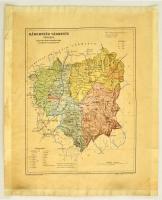
cca 1900-1910 Háromszék vármegye térképe,1:350.000. Magyar Földrajzi Intézet Rt., körbevágva, a széleken szakadással, a széleken ragasztás nyomaival, 33x26 cm.
cca 1900-1910 County map of Háromszék, 1:350.000, cut on edges, with tearings, traces, with stickings on the edges, 33x26 cm.
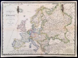
1860 Európa térképe, F. Fried, Wien, Artaria & Comp., német nyelven, foltos, a hátoldalán javítással, 37x50 cm./
1860 Map of Europe, F. Fried, Wien, Artaria & Comp., in German language, spotty, with repairs on the back, 37x50 cm.
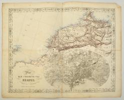
cca 1845-1847 Joseph Scheda (1815-1888): Plan der Umgebung von Neapel. Nápoly és kornyékének, valamint Északnyugat Afrika térképe, litográfia. Wien, K. K. Militärisch Geographisches Institut, foltos, kis szakadásokkal, német nyelven, 45x55 cm./
cca 1845-1847 Joseph Scheda (1815-1888): Plan der Umgebung von Neapel. Map of surroundings of Naples, and Northwest Africa, lithography. Wien, K. K. Militärisch Geographisches Institut, spotty, with a little tears, in German language, 45x55 cm./
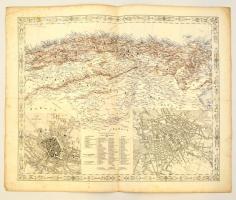
cca 1845-1847 Joseph Scheda (1815-1888): München és Berlin, és Észak Afrika térképe, litográfia. Wien, K. K. Militärisch Geographisches Institut, foltos, kis szakaadásokkal, német nyelven, 45x55 cm./ cca 1845-1847 Joseph Scheda (1815-1888): Map of München and Berlin, and North Africa, lithography. Wien, K. K. Militärisch Geographisches Institut, spotty, with a little tears, in German language, 45x55 cm./