https://www.darabanth.com/
https://static.darabanth.com/
https://static.darabanth.com/auction/img/
https://www.darabanth.com/
Continuous online auctions
Tétel

1849 Franciaország térképe, General-karte von Frankreich, F. Handtke,...

The item is not available

Catalogue number:

12689.
300. Closed Online auction
Maps

Starting price:

4 000 HUF
10,81 EUR, 11,76 USD

Number of bids:

0

Description:

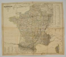
1849 Franciaország térképe, General-karte von Frankreich, F. Handtke, Glogau, Carl Flemming, hajtásnyomokkal, a hajtások mentén szakadással, a hátoldalon javítással, 67x80 cm./ 1849 Map of France, General-karte von Frankreich, F. Handtke, Glogau, Carl Flemming, with repairs on the back, folded, with some little tears, 67x80 cm.

Share:

Facebook

Photo of the item taken by : vörös_iván

further page navigation

Contact

Opening hours

  • Monday: 12-17
  • Tuesday-Wednesday: 10-17
  • Thursday: 10-19
  • Friday: closed
  • Weekend: closed

Our sites

© 2011-2024 Darabanth Philatelic and Numismatic Auctions Co., Ltd.
We use cookies on the Darabanth website to enhance your user experience.
By using this site you agree to the placement of cookies on your computer.
I agree
For details, please click here
https://www.darabanth.com/en/feltetelek/#privacy_policy
darabanth.com
Livestream

Item added to the basket

Basket cost in total:

Continue shopping
  To the payment