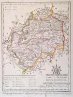
1810 Torna vármegye. Comitatus Tornensis. Színezett rézmetszet, papír, 24x31 cm Torna vármegye közigazgatási térképe emblémával (Szt. István felajánlja Magyarországot Szűz Máriának), a járások, utak, települések, vízrajz, domborzat (csíkozással) feltüntetésével, a budai kezdőmeridiánhoz igazítva. Csapó Benjámin (1758-?) munkája alapján metszette Benedicti Jeromos (cca 1756-1809), készítette Votésky Mihály (?-?). Görög Demeter (1760-1833) udvari tanácsos, kartográfus, polihisztor "Atlas Hungaricus seu regnorum Hungariae, Croatiae et Slavoniae comitatuum, privilegiatorum districtuum, et confiniorum generales particulares mappae geographicae. Magyar átlás az az Magyar, Horvát, és Tót országok' vármegyéji, 's szabad kerületei' és a' határ-őrző katonaság' vidékinek közönséges és különös tábláji" c. munkájából (Bécs, 1802-1811, Görög és Kerekes), a mű mecénásának, Festetics György gróf (1755-1819) mezőgazdásznak, a Georgikon alapítójának ajánlva. Kartonra ragasztva. /
1810 Comitatus Tornensis. Map of Torna County. Coloured copper etching, on paper,24x31 cm Map of Torna County, with an emblem (Saint Stephen dedicates Hungary to Virgin Mary), with the districts, roads, places, hydrogeology and relief of the county on it, adjusted to the meridian of Buda. Based on the work of Benjamin Csapó (1758-?), engraved by Jeromos (Hieronymus) Benedicti (cca 1756-1809), made by József Votésky (?-?). From the work of Demeter Görög (1760-1833) councillor, polymath, cartographer, entitled "Atlas Hungaricus seu regnorum Hungariae, Croatiae et Slavoniae comitatuum, privilegiatorum districtuum, et confiniorum generales particulares mappae geographicae. Magyar átlás az az Magyar, Horvát, és Tót országok' vármegyéji, 's szabad kerületei' és a' határ-őrző katonaság' vidékinek közönséges és különös tábláji" (Hungarian Atlas or the ordinary and special maps of the counties of Hungary, Croatia, Slavonia and the privileged districts and the Military Frontiers, Wien, 1802-1811, Görög and Kerekes), dedicated to Count György Festetics (1755-1819), the maecenas of the work, agronomist, the founder and eponym of the Georgikon, a remarkable economic school in Hungary.
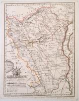
1810 Fejér vármegye. Comitatus Albensis. Színezett rézmetszet, papír, 24x31 cm Fejér vármegye közigazgatási térképe emblémával (Szt. István felajánlja Magyarországot Szűz Máriának), a járások, utak, települések, vízrajz, domborzat (csíkozással) feltüntetésével, a budai kezdőmeridiánhoz igazítva. Csapó Benjámin (1758-?) munkája alapján metszette Benedicti Jeromos (cca 1756-1809), készítette Votésky Mihály (?-?). Görög Demeter (1760-1833) udvari tanácsos, kartográfus, polihisztor "Atlas Hungaricus seu regnorum Hungariae, Croatiae et Slavoniae comitatuum, privilegiatorum districtuum, et confiniorum generales particulares mappae geographicae. Magyar átlás az az Magyar, Horvát, és Tót országok' vármegyéji, 's szabad kerületei' és a' határ-őrző katonaság' vidékinek közönséges és különös tábláji" c. munkájából (Bécs, 1802-1811, Görög és Kerekes), a mű mecénásának, Festetics György gróf (1755-1819) mezőgazdásznak, a Georgikon alapítójának ajánlva. Kartonra ragasztva. /
1810 Comitatus Albensis. Map of Fejér County. Coloured copper etching, on paper,24x31 cm Map of Fejér County, with an emblem (Saint Stephen dedicates Hungary to Virgin Mary), with the districts, roads, places, hydrogeology and relief of the county on it, adjusted to the meridian of Buda. Based on the work of Benjamin Csapó (1758-?), engraved by Jeromos (Hieronymus) Benedicti (cca 1756-1809), made by József Votésky (?-?). From the work of Demeter Görög (1760-1833) councillor, polymath, cartographer, entitled "Atlas Hungaricus seu regnorum Hungariae, Croatiae et Slavoniae comitatuum, privilegiatorum districtuum, et confiniorum generales particulares mappae geographicae. Magyar átlás az az Magyar, Horvát, és Tót országok' vármegyéji, 's szabad kerületei' és a' határ-őrző katonaság' vidékinek közönséges és különös tábláji" (Hungarian Atlas or the ordinary and special maps of the counties of Hungary, Croatia, Slavonia and the privileged districts and the Military Frontiers, Wien, 1802-1811, Görög and Kerekes), dedicated to Count György Festetics (1755-1819), the maecenas of the work, agronomist, the founder and eponym of the Georgikon, a remarkable economic school in Hungary.
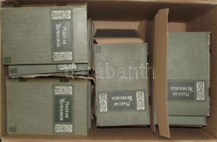
Magyar Remekírók sorozat. A magyar irodalom főművei. 1-55. kötet (hiány: 3,4,5,22,33,34,35,42-46).
Bp. 1905-1906. Franklin. Egységes, Gottermayer tulipános vászonkötésben 44 db Nagyon szép állapotban!
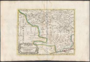
cca 1700 Johann Hofmann: Provance Olaszországban. Színezett rézmetszet. Megjelent: Atlas Curieux oder neuer und Compendieuser Atlas. (Augsburg, 1700?). Méret: 29x20 cm / cca 1700 Map of Provance in Italy. Colored etching 31x20 cm
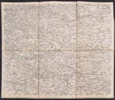
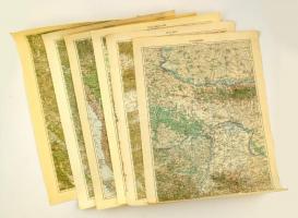
cca 1910 Katonai térképek gyűjteménye. Szerb és szlovén területek / Collection of military maps. Serbian and Slovenian areas. 6 pieces Kostajnica, Senj, Brod, Cilli, Mitrovica, Banja Luka, 63x48 cm
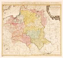
1773 Tobias Mayer; Homann Heirs: Carte des Etats de la couronne de Pologne, régi Lengyelország térkép. Színezett rézmetszet 51x47 cm /
1773 Tobias Mayer; Homann Heirs: Carte des Etats de la couronne de Pologne, map of Poland, Colored etching. 51x47 cm
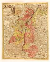
cca 1770 Georg Balthasar Probst (1732-1801): Landgraviatus Alsatiae tam superioris quam inferi cum utroqe Marchionatu Badensi...(Baden és Elzász térkép). Színezett rézmetszet. / cca 1770 Map of Alsace (Elsass) Colored etching. 37x44 cm