https://www.darabanth.com/
https://static.darabanth.com/
https://static.darabanth.com/auction/img/
https://www.darabanth.com/
Sold
12410.
296. Closed Online auction
Maps
10 000 HUF
2
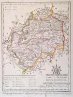
1810 Torna vármegye. Comitatus Tornensis. Színezett rézmetszet, papír, 24x31 cm Torna vármegye közigazgatási térképe emblémával (Szt. István felajánlja Magyarországot Szűz Máriának), a járások, utak, települések, vízrajz, domborzat (csíkozással) feltüntetésével, a budai kezdőmeridiánhoz igazítva. Csapó Benjámin (1758-?) munkája alapján metszette Benedicti Jeromos (cca 1756-1809), készítette Votésky Mihály (?-?). Görög Demeter (1760-1833) udvari tanácsos, kartográfus, polihisztor "Atlas Hungaricus seu regnorum Hungariae, Croatiae et Slavoniae comitatuum, privilegiatorum districtuum, et confiniorum generales particulares mappae geographicae. Magyar átlás az az Magyar, Horvát, és Tót országok' vármegyéji, 's szabad kerületei' és a' határ-őrző katonaság' vidékinek közönséges és különös tábláji" c. munkájából (Bécs, 1802-1811, Görög és Kerekes), a mű mecénásának, Festetics György gróf (1755-1819) mezőgazdásznak, a Georgikon alapítójának ajánlva. Kartonra ragasztva. / 1810 Comitatus Tornensis. Map of Torna County. Coloured copper etching, on paper,24x31 cm Map of Torna County, with an emblem (Saint Stephen dedicates Hungary to Virgin Mary), with the districts, roads, places, hydrogeology and relief of the county on it, adjusted to the meridian of Buda. Based on the work of Benjamin Csapó (1758-?), engraved by Jeromos (Hieronymus) Benedicti (cca 1756-1809), made by József Votésky (?-?). From the work of Demeter Görög (1760-1833) councillor, polymath, cartographer, entitled "Atlas Hungaricus seu regnorum Hungariae, Croatiae et Slavoniae comitatuum, privilegiatorum districtuum, et confiniorum generales particulares mappae geographicae. Magyar átlás az az Magyar, Horvát, és Tót országok' vármegyéji, 's szabad kerületei' és a' határ-őrző katonaság' vidékinek közönséges és különös tábláji" (Hungarian Atlas or the ordinary and special maps of the counties of Hungary, Croatia, Slavonia and the privileged districts and the Military Frontiers, Wien, 1802-1811, Görög and Kerekes), dedicated to Count György Festetics (1755-1819), the maecenas of the work, agronomist, the founder and eponym of the Georgikon, a remarkable economic school in Hungary.
Basket cost in total: