https://www.darabanth.com/
https://static.darabanth.com/
https://static.darabanth.com/auction/img/
https://www.darabanth.com/
Available
Add to cart Remove
10016.
42. Major auction sale of the unsold lots
Art, collectibles floor auction items
360 000 HUF
972,97 EUR, 1 058,82 USD
0
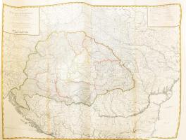
Magyarország, Erdély és Szlavónia rézmetszetű térképe. Bal felső sarkában kartus felirata : Wenzely, A(nton): Generalkarte von Ungarn, Siebenbürgen, Sclavonien & & : samt den angraenzenden Laendern nach den besten Karten, Original zeichnungen, und astronomische Beobachtungen, der Herrn Hell... A térkép 4 lapon jelent meg, ezek összeállítva adták kia hatalmas térképet. Képméret: 86,3×110,5 cm. Lapméret: 103,5×137.5 cm. A négy lap egyberagasztva, kiváló állapotban. Rendkívül ritka, dekoratív impozáns méretű térképünk helynevei számával is kitűnik a kor térképei közül Megjelent : Herrn F. A. Schraembl N. H. Benedicti és J. Gerstner atlaszában Bécsben 1790-ben
Basket cost in total: