https://www.darabanth.com/
https://static.darabanth.com/
https://static.darabanth.com/auction/img/
https://www.darabanth.com/
Continuous online auctions
Tétel

Le royaume de Hongrie divisé en Haute et Basse Hongrie, Transilvaniae,...

Sold

Catalogue number:

12278.
39. Closed major auction
Maps

Starting price:

40 000 HUF

Number of bids:

3

Description:

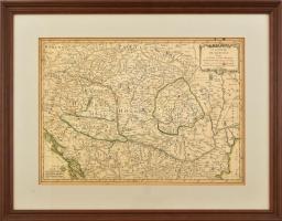
Le royaume de Hongrie divisé en Haute et Basse Hongrie, Transilvaniae, Esclavonie et Croatie. Dresse par le Sr Janvier Geographe.. Színezett réznyomat. Határszínezett. Megjelent Lattre, J.: Atlas Moderne... Paris, 1762. Néhány apró folttal, máskülönben jó állapotban. 31×44 cm / Map of Hungary, Transylvania, Croatia, Slavonia. Colored engraving. Framed. 31x44 cm

Share:

Facebook

Photo of the item taken by : pk

further page navigation

Contact

Opening hours

  • Monday: 12-17
  • Tuesday-Wednesday: 10-17
  • Thursday: 10-19
  • Friday: closed
  • Weekend: closed

Our sites

© 2011-2024 Darabanth Philatelic and Numismatic Auctions Co., Ltd.
We use cookies on the Darabanth website to enhance your user experience.
By using this site you agree to the placement of cookies on your computer.
I agree
For details, please click here
https://www.darabanth.com/en/feltetelek/#privacy_policy
darabanth.com
Livestream

Item added to the basket

Basket cost in total:

Continue shopping
  To the payment