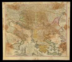
cca 1716 Magyarország, a Duna és a környező országok térképe. Johann Baptist Homann:
Homann, Joh. Bapt. (Hrsg.) :Fluviorum in Europa principis Danubii cum adiacentibus regnis nec non totius Graeciae et Archipelagi Novissima Tabula. Színezett rézmetszet. Foltos. Hiánnyal. Kartonon. / Map of the Danube River and the neighbouring countries and Greece . Colored copper plate engraving With stain and part missing, on cartboard. 62x55 cm