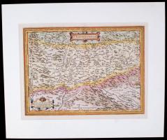
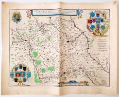
Ortelius, Abraham: Transilvania Hanc ultra vel Transilvaniam, que et pano Dacia et Dacia ripesis... Megjelent: A. Ortelius 1575 és 1595 között megjelent atlaszaiban, Antwerpen, 1575. Rajzolta: Johann Sambucus (Zsámboki János) szépen színezett rézmetszet. Paszpartuban. / Ortelius. Hand colored etched map of Transylvania after the drawing of Janos Zsamboki. In paspartu. Map size: 49x37 cm
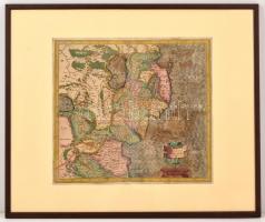
cca 1606 Gerhard Mercator (1512-1594) - (Hondius kiadása): Ultoniae orientalis pars. Militaria Irlandica - Írország keleti részének térképe. Színezett rézmetszet, szép állapotban, igényes üvegezett keretben. / Mercator - Hondius: Map of Ireland, Eastern Part. Handcolored etching. 40x36 cm In glazed frame 63x52 cm
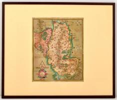
cca 1606 Gerhard Mercator (1512-1594) - (Hondius kiadása): Udrone Irlandiae in Caterlagh Baronia. Írország egy részének térképe. Színezett rézmetszet, szép állapotban, igényes üvegezett keretben. / Mercator - Hondius: Map of part of Ireland, Handcolored etching. 29x36 cm In glazed frame 64x53 cm
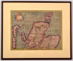
cca 1606 Gerhard Mercator (1512-1594) - (Hondius kiadása): Scotiae Regnum - Skócia térképe. Színezett rézmetszet, szép állapotban, igényes üvegezett keretben. / Mercator - Hondius: Map of Scotland, Handcolored etching 46x36 cm In glazed frame 63x52 cm
1634 Galloflandria in qua Castellinae. Willelm Blaeu (1571-1638) térképe Németalföldről, a népszerű Theatrum orbis terrarum, sive atlas novus in quo tabulae et descriptiones omnium regionum (Amsterdam, 1634) c. munkából, szanezett rézmetszet, hátulján Flandria rövid latin nyelvű történetével, 46x57 cm /
1634 Galloflandria in qua Castellinae. Willelm Blaeu's (1571-1638) map of Flandria, from the popular Theatrum orbis terrarum, sive atlas novus in quo tabulae et descriptiones omnium regionum (Amsterdam, 1634), with a brief history of Flandria in Latin on the back, Hand colored engraving. 46x57 cm
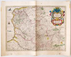
1634 Comitatus Artesia vulgo Artois. Willelm Blaeu (1571-1638) térképe Németalföldről, a népszerű Theatrum orbis terrarum, sive atlas novus in quo tabulae et descriptiones omnium regionum (Amsterdam, 1634) c. munkából, színezett rézmetszet, hátulján Artois rövid latin nyelvű történetével, 46x57 cm /
1634 Comitatus Artesia vulgo Artois. Willelm Blaeu's (1571-1638) map of Artois, from the popular Theatrum orbis terrarum, sive atlas novus in quo tabulae et descriptiones omnium regionum (Amsterdam, 1634), handcolored etching with a brief history of Artois in Latin on the back, 46x57 cm
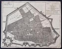
Citta e Cittadella di Ferrara. Ferrara városának és erődjének térképe. XVII. századi rézmetszet. 24x30 cm. The map of Ferrara, Italy, the 17th century. Paper.
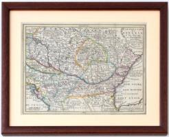
cca 1700 Le Royaume de Hongrie et des Pays qui en dependoient autrefois dressée sur les observations de l' Academie Royale des Sciences. Színezett rézmetszet, üvegezett keretben, 22x17 cm, keret: 30x24 cm /
cca 1700 Engraved mat pi Hungary Transylvania and the neighbouring states. Colored engraving in glazed frame 30x24 cm
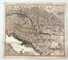
cca 1700 Johann Baptist Homann (1664-1724): Magyarország és a Duna medence térképe. Szép, erős rézmetszet, benne kézzel színezett határvonalakkal. Néhány javított szakadással / cca 1700 Danubii Fluminis (ab urbe Lentia usque et ultra Bydanam urbem cum influentibus fluviis delineanti)... Etched map of the Danube Basin, Hungary, Croatia, Bosnia, Transylvania. With some repaired tears. Nice strong print 58x55 cm
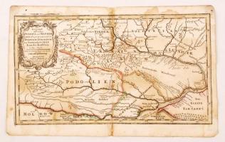
cca 1700 Johann Hofmann: Lengyelország, Podolia és a környező államok. Színezett rézmetszet. Megjelent: Atlas Curieux oder neuer und Compendieuser Atlas. (Augsburg, 1720?). Méret: 29x20 cm Foltos. / cca 1700 Map of Podolia and neighbouring area / Die gegend zwischen Pultava und Bender... colored etcing 29x20 cm Stained
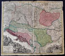
cca 1700 Nova et accurata Hungariae cum adiacentibus Regnis et Principatibus Tabula aeri incisa et venum exposita a Mattheus Seutter Calchographo Augustano. Magyarország és a társult országok térképe. Színezett rézmetszet, félbe hajtva, Tetején egy-két szakadással. / Colored etched map of the Kingdom of Hungary and the attached kingdoms. With some small tears 60x52 cm
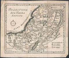
Palestina seu Terra Sancta. Palestina és a Szent Föld térkép. XVIII. század. Rézmetszet. Papír, 15x18 cm. Palestine and the Holy Land, the 18th. century, paper.
Darabanth Kft. a weboldalán cookie-kat használ annak érdekében, hogy a weboldal a lehető legjobb felhasználói élményt nyújtsa. Amennyiben Ön folytatja a böngészést a weboldalunkon, azt úgy tekintjük, hogy nincs kifogása a tőlünk érkező cookie-k fogadása ellen.