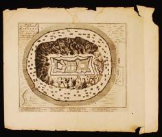
1692 Nicolas de Fer: Plan de la Fortresse Mongats - A munkácsi vár tervrajza. Az Introduction á la fortification c. munkájából. Paris, 1692. Rézmetszet. Méret: 20×25 cm. Lapméret: 34x29 cm. / Map of Munkacevo. Etching
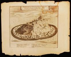
1692 Nicolas de Fer: Profil de la Fortresse Mongats - A munkácsi vár tervrajza. Az Introduction á la fortification c. munkájából. Paris, 1692. Rézmetszet. Méret: 20×25 cm. Lapméret: 34x29 cm. / Map of Munkacevo. Etching
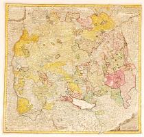
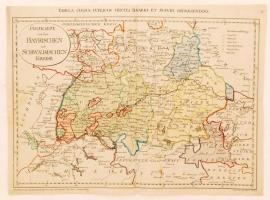
1743 Homann Heredibus: A Sváb Hercegség térképe Circuli Sveviae Mappa ex subsidiis Michalianis delineata... Színezett rézmetszet. / 1743 Homann Heirs: Map of Württemberg and the Swabish principality. Colored etching 55x52 cm
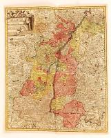
cca 1770 Georg Balthasar Probst (1732-1801): Landgraviatus Alsatiae tam superioris quam inferi cum utroqe Marchionatu Badensi...(Baden és Elzász térkép). Színezett rézmetszet. / cca 1770 Map of Alsace (Elsass) Colored etching. 37x44 cm
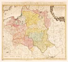
1773 Tobias Mayer; Homann Heirs: Carte des Etats de la couronne de Pologne, régi Lengyelország térkép. Színezett rézmetszet 51x47 cm /
1773 Tobias Mayer; Homann Heirs: Carte des Etats de la couronne de Pologne, map of Poland, Colored etching. 51x47 cm
1799 Franz Müller: Postkarte von den Bayrischen und Schwaebischen Kreise (Tabula cursus circuli Bavarici et Suevici repraesentans), Bajorország térképe. Színezett rézmetszet. 51x38 cm /
1799 Map of Bavaria. Franz Müller. Colored etching 51x38 cm
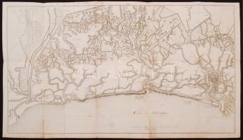
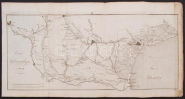
cca 1800 Velence és környékének vízrajzi térképe, a nagyobb csatornák feltüntetésével, rézmetszet, papír, 48×85 cm /
cca 1800 The hydrogrographical map of Venice and her surroundings, the main canals are marked, copper etching, on paper, 48×85 cm
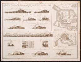
cca 1800 Profils des digues de la mer sur les îsles pres de Venise nominées Lidi, a Velence partjainál található homokzátonyból képződött turzásszigetek (Lido, Malamocco) védműveinek és az ott található hullámok keresztmetszetes rajzai, mellette keretes térképen Trieszt és a Szentpétervár melletti Kronstadt kikötővárosainak térképével, rézmetszet, papír, 47×63 cm /
cca 1800 Profils des digues de la mer sur les îsles pres de Venise nominées Lidi, the cross-sectional view of the dykes of the spit islands formed from sandbars (Lido, Malamocco) near the shores of Venice and the waves which could be found there, with the small framed maps of the port cities of Trieste and Kronstadt near Sankt Petersburg, copper etching, on paper, 47×63 cm
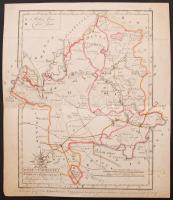
1802 Békés vármegye. Comitatus Békésiensis. Színezett rézmetszet, papír, 31×26,5 cm Békés vármegye közigazgatási térképe megyecímerrel, a járások, utak, települések, vízrajz, domborzat feltüntetésével, a budai kezdőmeridiánhoz igazítva. Vertics József (1745?-1829) földmérő munkája alapján metszette Berken (Berkeny) János (1765-1822), készítette Winter János mérnök. Görög Demeter (1760-1833) udvari tanácsos, kartográfus, polihisztor "Atlas Hungaricus seu regnorum Hungariae, Croatiae et Slavoniae comitatuum, privilegiatorum districtuum, et confiniorum generales particulares mappae geographicae. Magyar átlás az az Magyar, Horvát, és Tót országok' vármegyéji, 's szabad kerületei' és a' határ-őrző katonaság' vidékinek közönséges és különös tábláji" c. munkájából (Bécs, 1802-1811, Görög és Kerekes), a mű mecénásának, Festetics György gróf (1755-1819) mezőgazdásznak, a Georgikon alapítójának ajánlva. /
1802 Comitatus Békésiensis. Map of Békés County. Coloured copper etching, on paper, 31×26,5 cm Map of Békés County, with the coat of arms of the county, with the districts, roads, places, hydrogeology and relief of the county on it, adjusted to the meridian of Buda. Based on the work of József Vertics (1745?-1829) surveyor, engraved by János Berken/Berkeny (1765-1822), made by János Winter engineer. From the work of Demeter Görög (1760-1833) councillor, polymath, cartographer, entitled "Atlas Hungaricus seu regnorum Hungariae, Croatiae et Slavoniae comitatuum, privilegiatorum districtuum, et confiniorum generales particulares mappae geographicae. Magyar átlás az az Magyar, Horvát, és Tót országok' vármegyéji, 's szabad kerületei' és a' határ-őrző katonaság' vidékinek közönséges és különös tábláji" (Hungarian Atlas or the ordinary and special maps of the counties of Hungary, Croatia, Slavonia and the privileged districts and the Military Frontiers, Wien, 1802-1811, Görög and Kerekes), dedicated to Count György Festetics (1755-1819), the maecenas of the work, agronomist, the founder and eponym of the Georgikon, a remarkable economic school in Hungary.
1809 Carte hydrographique, az Adige folyó alsó folyásának vízrajzi térképe Veronától a torkolatig, a főbb csatornák és a balparti mellékfolyók feltüntetésével, rézmetszet, papír, 24×57 cm /
1809 Carte hydrographique, the hydrogeological map of the lower part of the Adige river from Verona to the mouth, the main canals and left tributaries are marked, copper etching, on paper, 24×57 cm
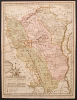
1810 Fejér vármegye. Comitatus Albensis. Színezett rézmetszet, papír, 29×22 cm Fejér vármegye közigazgatási térképe emblémával (Szt. István felajánlja Magyarországot Szűz Máriának), a járások, utak, települések, vízrajz, domborzat (csíkozással) feltüntetésével, a budai kezdőmeridiánhoz igazítva. Csapó Benjámin (1758-?) munkája alapján metszette Benedicti Jeromos (cca 1756-1809), készítette Votésky Mihály (?-?). Görög Demeter (1760-1833) udvari tanácsos, kartográfus, polihisztor "Atlas Hungaricus seu regnorum Hungariae, Croatiae et Slavoniae comitatuum, privilegiatorum districtuum, et confiniorum generales particulares mappae geographicae. Magyar átlás az az Magyar, Horvát, és Tót országok' vármegyéji, 's szabad kerületei' és a' határ-őrző katonaság' vidékinek közönséges és különös tábláji" c. munkájából (Bécs, 1802-1811, Görög és Kerekes), a mű mecénásának, Festetics György gróf (1755-1819) mezőgazdásznak, a Georgikon alapítójának ajánlva. /
1810 Comitatus Albensis. Map of Fejér County. Coloured copper etching, on paper, 29×22 cm Map of Fejér County, with an emblem (Saint Stephen dedicates Hungary to Virgin Mary), with the districts, roads, places, hydrogeology and relief of the county on it, adjusted to the meridian of Buda. Based on the work of Benjamin Csapó (1758-?), engraved by Jeromos (Hieronymus) Benedicti (cca 1756-1809), made by József Votésky (?-?). From the work of Demeter Görög (1760-1833) councillor, polymath, cartographer, entitled "Atlas Hungaricus seu regnorum Hungariae, Croatiae et Slavoniae comitatuum, privilegiatorum districtuum, et confiniorum generales particulares mappae geographicae. Magyar átlás az az Magyar, Horvát, és Tót országok' vármegyéji, 's szabad kerületei' és a' határ-őrző katonaság' vidékinek közönséges és különös tábláji" (Hungarian Atlas or the ordinary and special maps of the counties of Hungary, Croatia, Slavonia and the privileged districts and the Military Frontiers, Wien, 1802-1811, Görög and Kerekes), dedicated to Count György Festetics (1755-1819), the maecenas of the work, agronomist, the founder and eponym of the Georgikon, a remarkable economic school in Hungary.
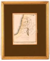
1836 A Map of Canaan, adapted to the Book of Judges. Kánaán térképe a Bírák Könyves szerint, a Calmet's Dictionary of the Holy Bible (Ed. Taylor, Charles. London, 1836, Holdsworth) c. könyv 196. térképmelléklete, paszpartuban, üvegezett fa keretben, 22,5×17,5 cm /
1836 A Map of Canaan, adapted to the Book of Judges. The 196th map from the Calmet's Dictionary of the Holy Bible (Ed. Taylor, Charles. London, 1836, Holdsworth), in a glassed wooden frame, 22,5×17,5 cm
Darabanth Kft. a weboldalán cookie-kat használ annak érdekében, hogy a weboldal a lehető legjobb felhasználói élményt nyújtsa. Amennyiben Ön folytatja a böngészést a weboldalunkon, azt úgy tekintjük, hogy nincs kifogása a tőlünk érkező cookie-k fogadása ellen.