1566 Erdély színezett rézmetszetű térképe. HANC VLTRA VEL TRAN-/ SILVANIAM, QVAE ET PANO-/ DACIA, ET DACIA RIPESIS, VVL-/ GO SIBEMBVRGE DICITUR, / edidit Vienne A. 1566. Nobiliss. Atq. Doctiss. / Ioes Sabucus / Pannonius. Hátlapján Erdélyről szóló latin nyelvű leírás. Rézmetszet. Zsámboki János rajza után metszette Franz Hogenberg. Megjelent Antwerpenben, Ortelius atlaszaiban. Méret: 448 × 326 mm, szép állapotban / 1566 Colored engraving map of Transylvania. Ortelius after Zsamboki.
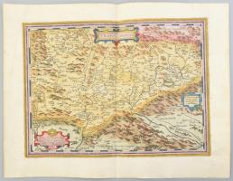
~1611 Erdély színezett rézmetszetű térképe. Mercator, Gerhard. Transylvania / Sibenburgen. Erdély címerével és allegrikus nőalakokkal díszített keretben. Hátoldalán francia nyelvű leírással Megjelent:Mercator: Atlas, sive Cosmographicae Meditationes de Fabrica Mundi... Amszterdam, 1628. Hondius. 424x337 mm, Lapméret 566x480 mm / 1611 Hand colored copper plate engraved map of Transylvania, with French description.
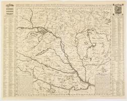
1708 Nouvelle carte de la Hongrie divisee selon ses differents Etats, avec une chronologie de ses Ducs et de ses Rois, dans la'quelle on voit aussi par des tables alphabetiques, les archeveschez, evechez, universitez, et les batailles les plus memorables. In: Z. Chatelain: Atlas Historique, ou Nouvelle Introduction a l'Histoire, á la Cronologie & á la géographie. Ancienne & Moderne. A jobb felső sarokban: Tome 2. No. 38. (Amsterdam, 1708, Z. Chatelain.), rézmetszetű térkép, csak a térkép: 44x48,5 cm, szöveggel együtt: 48x62,5 cm, lapméret: 52x65 cm. Rézmetszetű térkép, francia nyelven, a felső sarkokban a Magyar királyság valamint a román királyok címerével, szélein a városok, folyók jegyzékével, valamint csaták és ostromok, és királyok jegyzékével. A térképen a fontosabb események évszámaival. Jó, megkímélt állapotban / 1708 engraved map of Hungary and Transylvania with the coat of arms of Hungarian and Romanian kings
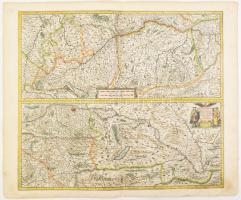
1666 A Duna Németországi és Magyarországi folyásának kétosztatú, színes rézmetszetű térképe. - Maximi totius Europe fluminis Danubii cursus per Germaniam Hungariamque. Megjelent : Janssonius, Johannes : Atlas contractus, sive atlantis majoris comprendium... c. munkájában, Amszterdam, 1666. 440x450 mm. Lapméret: 590x500 mm. / 1666 Copper plate engraved map of the course of Danube in Hungary. Germany and Transylvania
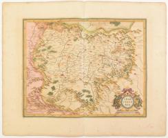
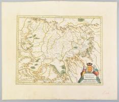
1724 Erdély rézmetszetű térképe. de Fer, Nicolas (1646-1720): Principauté de Transilvanie sivisée en cinq nations subdividée en quartiers et comtez... N. de Fer Geographe ... metszette Danet, Guillaume (c. 1670-1732). Megjelent: Fer, Nicolas de: Sphere Royalle. 494x442 mm, lapméret 715x527 mm. Kis gyűrödésekkel / Copper plate engraving map of Transylvania
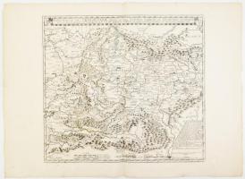
A Duna medence térképe Magyarországgal, Erdéllyel, Romániával és a Balkánnal. Homann, Joh. Baptist: Danubii Fluminis (hic ab urbe Belgrado per mare Nigrum usqu Constantinapolim defluentis exhibiti). Pars infima. Transsylvania, Wallachia, Moldavia, Bulgaria, Servia, Romania et Bessarabia... Nürnberg, 1713. Színezett rézmetszet, egy helyen ujjnyi papírelvékonyodással . 580x471 mm, lapméret 640x540 mm. / 1713 Map of the Danube and neigbouring countries. Wallachia, Moldavia, Serbia,. Transylvania. Colored engraving with a slight paper wear
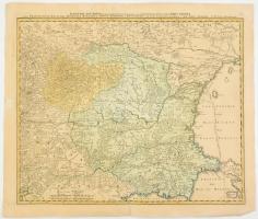
1822 Magyarország (és Erdély) közigazgatási térképe. Carte des divisions intérieures administratives, militaires, etc des Provinces Hongraises. Beudant, François-Sulpice (1787-1850) Megj.: Beudant, F. S.: Voyage mineralogique et géologique en Hongrie, Paris, 1822 Verdi?ere. Rézmetszet 359x254 mm, lapméret 406x287 mm / Copper plate engraved map of Hungary incl. Transylvania
1636 Erdély színezett rézmetszetű térképe. Mercator, Gerhard. Transylvania / Sibenburgen. Erdély címerével és allegrikus nőalakokkal díszített keretben. Hátoldalán francia nyelvű leírással Megjelent: Mercator-Hondius Atlas. Amsterdam, 1636.H. Hondius. 425x338 mm, Lapméret 566x480 mm / 1636 Hand colored copper plate engraved map of Transylvania, with French description.
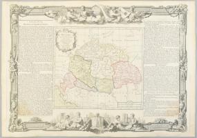
Brion de la Tour, Louise (1743-1830): La Hongrie avec les Provinces adjacentes: formant tout ensemble ... Magyarország, Erdély és a szomszédos országok térképe, körül francia nyelvű országleírásokkal. Megjelent: Atlas général et élémentaire pour l'Etude de la géographie et de l'histoire moderne di Louis Brion de la Tour, 1766. Színezett rézmetszet, szép állapotban 510x370 mm, 554x380 mm / Copper plate engraved map of Hungary, Transylvania.