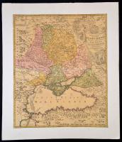
1720 Johann Baptist Homann: Oroszország és a Fekete tenger környékének térképe. Tabula Geographica qua pars Russiae Magnae Pontus Euxinus seu mare Nigrum et Tartaria Minor cum finitimis Bulgariae, et Romaniae et Natoliae... Színezett rézmetszet kartonra ragasztva. /
1720 Map of Russia and the Black Sea area. Colored etching. 49x58 cm
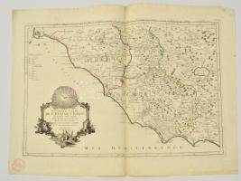
Paolo Santini: Castello, Perousia, Umbria, Orvieto és Nápoly térképe. Carte de l'Etat de l'Eglise... Színezett rézmetszet / Large etched map of Northern-Italy. Colored etching in good condition. 70x50 cm
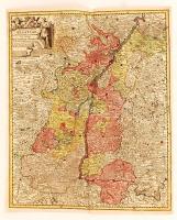
Gröningen és környékének nagyméretű, díszes térképe. Frederick De Wit: Tabulae Dominii Groeningae quae et Complectitur Maximam Partem Drentiae Emendata A.F. De Wit. Rézmetszet, néhán ykisebb szakadással / Large etched map of Gröningen Germany. Small tears. 60x52 cm
Homann Johann Babtiste (1664-1724 ) Principatus et archiepiscopatus Salisburgensis. / Salzburgi hercegség és püspökség térképe. Néhány képet nem érő beszakadással. Színezett rézmetszet. 58x49 cm /
cca 1710 Homann Johann Babtiste (1664-1724): Map of the Princedom of Salzburg. Colored etshing, with some, minor and out of the map tears at the edges. 58x49 cm
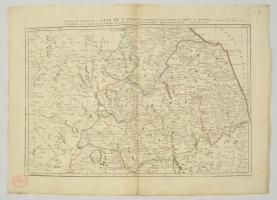
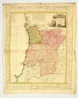
1800 Három portugál tartomány térképe. Provincias septentrionales de Portugal, Beira, Tras los Montes & Entre Douro Minho.. Homann Heirs 1800.. Nagyméretű színezett rézmetű térkép. Szélén magyar és német nyelvű fokjelzéssekkel. Kis hiánnyal / Map of 3 Portugal states. With handwritten notes on the side and small part missing. Large colored etching. 68x59 cm
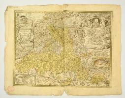
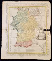
1800 Portugál tartomány térképe. Les Provinces méridionales de Portugal, savoir - Dressée nouvellement par F. L. Güssefeld. Homann Heirs 1800. Nagyméretű színezett rézmetű térkép. Szélén magyar és német nyelvű fokjelzéssekkel. Kis hiánnyal / Map of Portugal states. With handwritten notes on the side and small part missing. Large colored etching. 68x59 cm
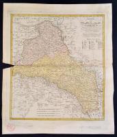
1800 Galicia térképe. Franz L Gussefeld: Charte von Ost- und West- oder Alt- und Neu-Galizien. Nurnberg : Homann. Erben, 1800. Színezett rézmetszet, kis hiánnyal. / Map of Galicia (Poland, Ukraine) Large etching with small part missing. 48x54 cm
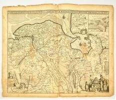
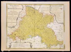
Homann, Johann Baptist (1663-1724): Csehország, Morvaország térképe. Rézmetszetű térkép. Paszpartuban. / Regni Bohamiae circulus Regnio Hredecensis ex Müllerianis... Map of the Czech and Moravian Kingdom. On cartboard. With some damages. 60x46 cm
Paolo Santini: Róma, Abruzzia és a Pápai Állam térképe. Paolo Santini: Nouvelle Carte De L'Etat de L'Eglise, Dressee Sur Celle Du P. Boscovich, divisee en trois feuilles . . . 1776 Színezett rézmetszet / Large etched map of Roma and the Papal State in Italy. Colored etching in good condition. 70x50 cm
cca 1770 Georg Balthasar Probst (1732-1801): Landgraviatus Alsatiae tam superioris quam inferi cum utroqe Marchionatu Badensi...(Baden és Elzász térkép). Színezett rézmetszet. / cca 1770 Map of Alsace (Elsass) Colored etching. 37x44 cm
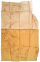
XIX. sz. Tlács, Acsuca, Gyalu Talácsului erdélyi település telkeinek kézzel rajzolt térképe pausz papíron / Hand drawn map of Transylvanian village 78x47 cm
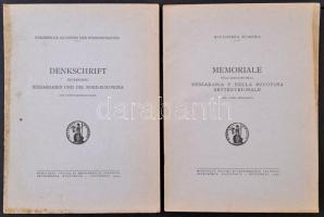
Memoriale sulla questione della Bessarabia e della Bucovina settentrionale. Bukarest, 1940, Accademia romena. Vitairat Besszarábia és Észak-Bukovina szovjet megszállásáról, Besszarábia és Észak-Bukovina néprajzi térképével. Tűzött papírkötésben, felvágatlan példány. + A vitairat német nyelvű verziója: Denkschrift betreffend Bessarabien und die Nord-Bukowina (térképmelléklet nélkül)