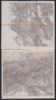
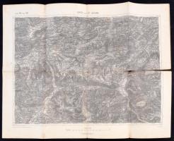
cca 1890 2 érdekes térkép: Laibach. Villach, valamint Korfu és a Balkán félsziget vászon téképe. Szép állapotban. / Map of Laibach and area and the Balkan peninsula 41x37 cm
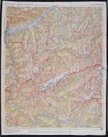
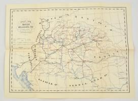
1871 Orts & Strassen Karte der Königreiche Ungarn, Croatien und Slavonien, des Grossfürstenthums Siebenbürgen. -
A Magyar királyság, Horvátország, Szlavónia, az Erdélyi fejedelemség és a Határőrvidék helyiség és úthálózati térképe.
Bearbeitet von A. Steinhauser. Bécs, 1871. Artaria & Comp. Színes, lithografált térkép, vászonra kasírozva, hajtogatva aranyozott egészvászon borítással. Nagyon szép állapotban. /
1871 Lithographic map of the KIngdom of Hungary, Croatia, Transylvania, Slavonia and the Militaryborder area. In nice linen cover. In very nice condition. Map size 78x54 cm
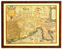
1573 Ortelius, Abraham (1527-1598) - Zsámboky János (1531-1584): Fori Iulii accurata descriptio, színezett rézmetszetes térkép, hátoldalán Friuli történetével, hajtásnyommal, kis lyukkal, egy helyütt utólagos színezéssel, üvegezett fa keretben, 39×52 cm /
1573 Ortelius, Abraham (1527-1598) - Zsámboky, János (Johannes Sambucus, 1531-1584): Fori Iulii accurata descriptio, map of Friuli, coloured copper etching, with the history of Friuli on its back (in Latin), with folding line and a little hole, part of it coloured later, in glassed wooden frame, 39×52 cm
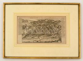
cca 1700-1730 Gabriel Bodenehr (1664-1758): Vilnius térképe, 'Wilna oder Wilda die Haupt-stadt in Litthauen', Augsburg, Europens Pracht und Macht c. kiadványból, 191 p., rézmetszet, német nyelven, üvegezett fa képkeretben, paszpartuban, 17x30 cm./
cca 1700-1730 Gabriel Bodenehr (1664-1758): Map of Vilnius, 'Wilna oder Wilda die Haupt-stadt in Litthauen', Augsburg, from the book of Europens Pracht und Macht, 191 p., copper-engraving, in German language, in wooden frame with glass, in paspartu, 18x29 cm.
cca 1700-1730 Gabriel Bodenehr (1664-1758): Grodno térképe, Grodno 'Eine der Fürnehmbsten Staedte in Lithauen', (Ma Fehérororszország), Augsburg, Europens Pracht und Macht c. kiadványból, 74 p., rézmetszet, német nyelven, üvegezett fa képkeretben, paszpartuban, 18x29 cm./
cca 1700-1730 Gabriel Bodenehr (1664-1758): Map of Grodno 'Eine der Fürnehmbsten Staedte in Lithauen', (Today Belraus), Augsburg, from the book of Europens Pracht und Macht, 74 p., copper-engraving, in German language, in wooden frame with glass, in paspartu, 18x29 cm.
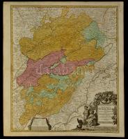
cca 1740 Johann Georg Schreibern (1676-1750): A Porosz Királyság a lengyel részekkel együtt, színezett rézmetszet, paszpartuban, német nyelven, 18x26 cm./
cca 1740 Johann Georg Schreibern (1676-1750): The Kingdom of Preussen together with the polish part, colored copper-engraving, in paspartu, in German language, 18x26 cm.
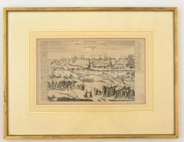
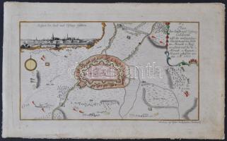
1757 Geldern német város és erőd térképe, színezett rézmetszet, Nürnberg, Raspischen Buchhandlung, német nyelven, 17x30 cm./
1757 Map of Geldern german city and fortress, colored copper-engraving, Nürnberg, Rapischen Buchhandlung, in German language, 17x30 cm.
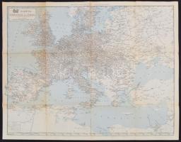
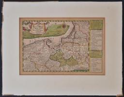
1720 Burgundia térképe. Johann Baptist Homann:
Comitatus Burgundiae tam in primarias ejus praefecturas, quam in minores ejus balliviatus aliasque, Ditiones subjacentes et infertas a vicinis Regionibus accurate et distincte divisi. Színezett rézmetszet / Map of Burgundia Colored copper plate engraving 62x55 cm