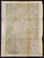
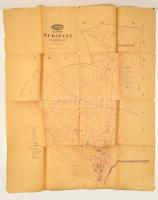
1915 Katonai térképek, összesen 5 db Szombathely, Budapest, Pozsony, Magyaróvár, Budapest Észak (és környéke) katonai térképek. Vegyes állapotban, A. M. Kir. Állami Térképészet, 1:200.000, 62x47cm
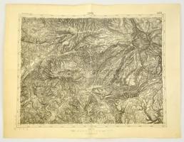
cca 1910 Szováta és környéke katonai térképe, 1:75.000, K.u.K. Militärgeographisches Institut, 47x62 cm / cca 1913 Military map of Sovata, 1:75.000, K.u.K. Militärgeographisches Institut, 47x62 cm
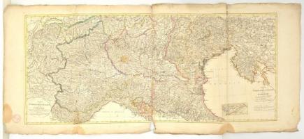
1803 Észak-Itália vagy Lombardia térképe, készítette Conrad Mannert, Nürnberg, Schneider und Weigels, színezett rézmetszet, sérült, 49x117 cm./
1803 Northern Italy or Lombardy, made by Conrad Mannert, Nürnberg, Schneider und Weigels, colored copper plate engraving, 49x117 cm.
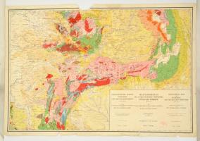
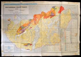
cca 1928 Magyarország és a vele határos területek földtani térképe, öszeáll: M. Kir. Földtani Intézet, 1914-es határok szerint, Bp. M. Kir. Földtani Intézet, egy lap, négy lapban teljes, szakadt, sérült, hiányos, 63x94 cm.
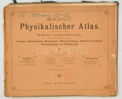
1886-1887 Berghaus Physikalischer Atlas. I. rész (II.,III., V.,VI.,XIII.,XV. térképek.), II. rész (I.,IV.,VIII-XI. térképek),III. rész (X-XII. térképek), IV. rész (V. térkép), VI. rész (I-IX. térképek), VII. rész (VI-XI. térképek.), összesen: 31 db térkép. Nem teljes! Szerk.: Prof. Dr. Hermann Berghaus. Gotha, Justus Perthes. Szakadozott papírmappákban, de a térképek jó állapotban, német nyelven, 33x41 cm./
1886-1887 Berghaus Physikalischer Atlas. I. part (II.,III.,V.,VI.,XIII.,XV. maps), II. part (I.,IV.,VIII-XI. maps), III. part (X-XII. maps), IV. part (V. map), VI. part (I-IX. maps), VII. part (VI-XI. Maps.) All: 31 pc. maps. Not complete! Edited by Prof. Dr. Hermann Berghaus. Gotha, Justus Perthes. In raunchy folders, but the maps are okay, in German language, 33x41 cm.
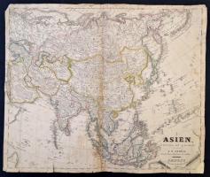
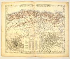
1829 Ázsia térképe, (rajta többek között Kína, Japán, India, és Oroszország..stb), F. W. Streit, Leipzig, J. C. Hinrichssche Buchhandlung, német nyelven, megviselt állapotban, sérült, a hátoldalán javított, 40x47 cm./
1829 Map of Asia, (with China, Japan, India, and Russian Empire), F. W. Streit, Leipzig, J. C. Hinrichssche Buchhandlung, in German language, in poor condition, damaged, with repairs on the back, 40x47 cm.
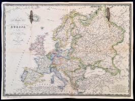
1860 Európa térképe, F. Fried, Wien, Artaria & Comp., német nyelven, foltos, a hátoldalán javítással, 37x50 cm./
1860 Map of Europe, F. Fried, Wien, Artaria & Comp., in German language, spotty, with repairs on the back, 37x50 cm.
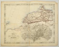
cca 1845-1847 Joseph Scheda (1815-1888): Plan der Umgebung von Neapel. Nápoly és kornyékének, valamint Északnyugat Afrika térképe, litográfia. Wien, K. K. Militärisch Geographisches Institut, foltos, kis szakadásokkal, német nyelven, 45x55 cm./
cca 1845-1847 Joseph Scheda (1815-1888): Plan der Umgebung von Neapel. Map of surroundings of Naples, and Northwest Africa, lithography. Wien, K. K. Militärisch Geographisches Institut, spotty, with a little tears, in German language, 45x55 cm./
cca 1845-1847 Joseph Scheda (1815-1888): München és Berlin, és Észak Afrika térképe, litográfia. Wien, K. K. Militärisch Geographisches Institut, foltos, kis szakaadásokkal, német nyelven, 45x55 cm./ cca 1845-1847 Joseph Scheda (1815-1888): Map of München and Berlin, and North Africa, lithography. Wien, K. K. Militärisch Geographisches Institut, spotty, with a little tears, in German language, 45x55 cm./
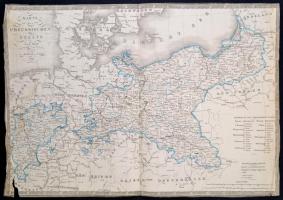
1839 Poroszország térképe, F. Fried, Wien, Artaria & Comp., német nyelven, két alsó sarkánál sérült, a széleinél kissé gyűrött, 36x50 cm./
1839 Map of Prussia, F. Fried, Wien, Artaria & Comp., in German language, with two damaged corner, with a little bit wrinkled edges, 36x50 cm.