https://www.darabanth.com/
https://static.darabanth.com/
https://static.darabanth.com/auction/img/
https://www.darabanth.com/
The item is not available
11912.
32. Closed major auction
Maps
100 000 HUF
270,27 EUR, 294,12 USD
0
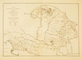
1725 A Kárpát-medence és a Dinári-hegység bányáinak térképe. Marsigli, Luigi Ferdinando (1658-1730): Danubius Pannonico-mysicus : observationibus geographicis, astronomicis, hydrographicis, historicis, physicis, perlustratus et in sex tomos digestus.Haga, 1726 c. munkájából. III. kötet 8. tábla. Nagyméretű rézmetszet. 67x47 cm. / Mines of Hungary and Croatia. Copper plate engraving. Az olasz Luigi Ferdinando Marsigli a török elleni felszabadító harcok idején hadmérnökként szolgált a császári seregben, 1691-ben az angol Royal Society tagjává választották, és Magyarország földrajzának tanulmányozására, adatgyűjtésre kérték fel. Hazánk térképeinek pontosítását segédjével, Johann Christoph Müllerrel közösen végezte el: Szép, tiszta metszet.
Basket cost in total: