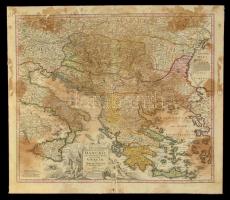
cca 1716 Magyarország, a Duna és a környező országok térképe. Johann Baptist Homann:
Homann, Joh. Bapt. (Hrsg.) :Fluviorum in Europa principis Danubii cum adiacentibus regnis nec non totius Graeciae et Archipelagi Novissima Tabula. Színezett rézmetszet. Foltos. Hiánnyal. Kartonon. / Map of the Danube River and the neighbouring countries and Greece . Colored copper plate engraving With stain and part missing, on cartboard. 62x55 cm
Die Webseite von Darabanth GmbH nutzt Cookies, um Ihnen die bestmögliche Surferfahrung zu garantieren. Durch das Weitersurfen auf dieser Webseite stimmen Sie der Verwendung der Cookies automatisch zu.