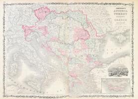
1863 Johnson Map of Austria, Turkey, and Greece. Ausztria, Magyarország, a Balkán és Törökország térképe. Színezett acélmetszet Constantinápoly látképével. / Colored map of Austria-Hungary with the image of Constantinople 67x47 cm
Die Webseite von Darabanth GmbH nutzt Cookies, um Ihnen die bestmögliche Surferfahrung zu garantieren. Durch das Weitersurfen auf dieser Webseite stimmen Sie der Verwendung der Cookies automatisch zu.