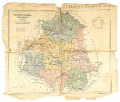
1738 Joan. van der Bruggen 1738: Regnum Hungariae, in quo continentur Regiones Servia, Walachia, Bulgaria, Transylvania, Moldavia, Sclavonia, Croatia, Bosnia, Dalmatia, quibus annexae sunt Podolia Bessarabia, et Macedonia, Maximáque pars Danub? usque ad Ostia ejus juxta modernam Hungariae formam. Magyarország és a környező országok színezett rézmetszetű térképe. 32x26 cm
Magyarország, a Duna és a Balkán félsziget térképe. Theatrum belli sive novissima tabula qua maxima pars Danubii et praeserti Hungaria cum aliis adiacentibus regnis... / a Matthaeo Seutter..Augustae Vindelic. [Augsburg] [ca 1728.]. Színezett rézmetszet. Szép állapotban. / Copper plate engraving in nice condition. 49x57 cm
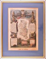
cca 1850 Départment du Garonne (Franciaország) térképe, Atlas National Illustre, 42x28 cm. Dekoratív üvegezett fakeretben, néhány apró folttal. /
cca 1850 Map of Départment du Garonne (France), Atlas National Illustre, framed, few small stains, 42x28 cm
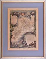
cca 1850 Départment du Rhone (Franciaország) térképe, Atlas National Illustre, 42x28 cm. Dekoratív üvegezett fakeretben, kissé foltos. /
cca 1850 Map of Départment du Rhone (France), Atlas National Illustre, framed, stains, 42x28 cm
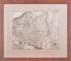
cca 1880 Oroszország és Skandinávia (Russland und Skandinavien), térkép a Stieler-féle iskolai atlaszból, Gotha: Justus Perthes kiadása, 1: 10.000.000, 33x40 cm. Dekoratív üvegezett fakeretben, lap kissé foltos. /
cca 1880 Map of Russia and Scandinavia, Stieler's Schul-Atlas No.36., Gotha: Justus Perthes edition, framed, stains 33x40 cm
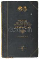
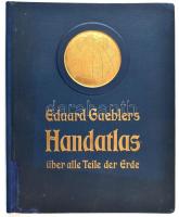
cca 1910 Eduard Gaeblers Hand-atlas über alle Teile der Erde. Leipzig, ,Eduard Gaebler Geographisches Institut, 2+XXXII p.+40 t. Siebente Auflage. Német nyelven. Javított gerincű, aranyozott egészvászon-kötésben, javított kötéssel.
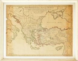
cca 1715 Guillaume Delisle (1675-1726) -Anselmo Maria Banduri (1675-1743): Orbis Romani descriptio seu divisio per themata sub Imperatoribus Constantinopolitanis post Heraclii tempora facta. Auctore Guillelmo Del'Isle e Regia Scientiarum Academia ad novam editionem operum Constantini Porphyrogeniti quae prodit Studio Anselmi Bandurii, Ragusini monachi Benedictini Melitensis cum ajusdem Notis et Animadversionibus, térkép, rézmetszet, kézzel színezett határokkal, üvegezett kopott fa keretben, kis foltokkal, a bal szélén kis hiánnyal, a bal felső sarkán kis süléssel és kis lyukkal, a jobb felső sarkán kis lyukkal, körbevágott, 47,5x62 cm, keret: 56x70 cm/ cca 1715 Guillaume Delisle (1675-1726) -Anselmo Maria Banduri (1675-1743): Orbis Romani descriptio seu divisio per themata sub Imperatoribus Constantinopolitanis post Heraclii tempora facta. Auctore Guillelmo Del'Isle e Regia Scientiarum Academia ad novam editionem operum Constantini Porphyrogeniti quae prodit Studio Anselmi Bandurii, Ragusini monachi Benedictini Melitensis cum ajusdem Notis et Animadversionibus, map, copper engraving, with coloured borders. The upper corners little bit damaged, with little lack on the right and left corners, little lack on the left margin, with little spotties, cut around, in little bit damaged wooden frame with glass, 47,5x62 cm, frame: 56x70 cm
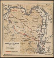

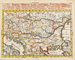
![Magyarország, a Duna és a Balkán félsziget térképe. Theatrum belli sive novissima tabula qua maxima pars Danubii et praeserti Hungaria cum aliis adiacentibus regnis... / a Matthaeo Seutter..Augustae Vindelic. [Augsburg] [ca 1728.]. Színezett rézmetszet. Szép állapotban. / Copper plate engraving in nice condition. 49x57 cm](https://static.darabanth.com/images_thumbs/2/5/2563937.jpg)