1804 Berken János (1765 kr.-1822): Nyitra vármegye térképe. C(omitatus) Nitriensis. Pars Occidentalis Westlicher Theil. VIII. In: [Korabinszky János Mátyás]: Korabinsky, Johann Matthias: Atlas Regni Hungariae Portatilis. Bécs, 1804. Schaumburg und Compagnie, rézmetszet, paszpartuban, apró folttal, 16,5x10,5 cm.
/ 1804 János Berken (1765 cca.-1822):Map of Nitra/Nyitra/Neutra. C(omitatus) Nitriensis. Pars Occidentalis Westlicher Theil. VIII. In: Korabinsky, Johann Matthias: Atlas Regni Hungariae Portatilis. Wien, 1804. Schaumburg und Compagnie, copper engraving, in passepartout, with small spotty, 16,5x10,5 cm.
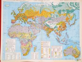
Larousse International atlas political and economical. Publié sous la direction de Ivan Du Jonchay, Sándor Radó. Hiányos térkép melléklettel, összesen 53 db térképet tartalmaz.Paris, 1965, Libraire Larousse. Kiadói egészvászon tékában
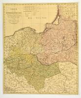
1798 Franz Ludwig Güssefeld (1744-1807): Charte von dem Königreich Preussen. Nach seiner Hauptabtheilung/ in Ost-West-Süd- und Neu-Ost-Preussen/ u. seinen Unterabtheilungen in Kreise./ Neu entworfen von F.L. Güssefeld/ 1798./ Nürnberg bey den Homann. Erben./ Mit Röm. Kayserl. allergnädigster/ Freyheit
Poroszország térképe. Színezett rézmetszet, körbevágott, kartonra kasírozva. / Large map of Prussian Kingdom. Colored etching. Cut margins. Glued on cartboard. 47x55 cm
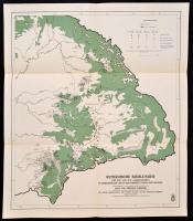
1943 Rumänische Siedlungen des XIII. und XIV. Jahrhunderts in Siebenbürgen und in den übrigen Teilen Ostungarns, lépték nélkül, a Siebenbürgen und seine Völker (Szerk.: Mályusz Elemér. Bp.-Lipcse-Mailand, 1943, Danubia) kötetből, 53×45,5 cm
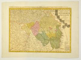
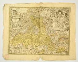
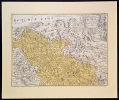
Homann, Johann Baptist (1663-1724) - Johann Christian Müller: Morvaország, Prerov környékének rézmetszetű térképe. Paszpartuban. / Marchionatus Moraviae Circulus Preroviensis Map of the Moravian Kingdom. Prerau area. Etching in paspartu. 60x46 cm
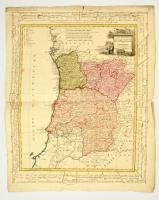
1800 Három portugál tartomány térképe. Provincias septentrionales de Portugal, Beira, Tras los Montes & Entre Douro Minho.. Homann Heirs 1800.. Nagyméretű színezett rézmetű térkép. Szélén magyar és német nyelvű fokjelzéssekkel. Kis hiánnyal / Map of 3 Portugal states. With handwritten notes on the side and small part missing. Large colored etching. 68x59 cm
Homann Johann Babtiste (1664-1724 ) Principatus et archiepiscopatus Salisburgensis. / Salzburgi hercegség és püspökség térképe. Néhány képet nem érő beszakadással. Színezett rézmetszet. 58x49 cm /
cca 1710 Homann Johann Babtiste (1664-1724): Map of the Princedom of Salzburg. Colored etshing, with some, minor and out of the map tears at the edges. 58x49 cm
Homann, Johann Baptist (1663-1724): Morvaország, a Brünni kerület rézmetszetű térképe. Paszpartuban. / Marchionatus Moraviae Circulus Brunnensis quem Mandato Cesaro accurate emmensis... Map of the Moravian Kingdom. Brünn area. Etching in paspartu. 60x46 cm
cca 1670 Utrecht és környékének térképe, Domini Ultraiectini tabula auctore Frederico de Wit Amsterodami. Nagyméretű rézmetszet, díszes kartussal. Paszpartu nélkül / Map of Utrecht and area. Large etching by Frederic de Wit. 56x46 cm
cca 1940 Der Mittelmeerraum mit Angaben über Flottenstützpunkte, kriegswichtige Bodenschätze und machtpolitische Zusammenhänge. Bielefeld und Leipzig, é.n., Velhagen und Klasing. Színes térkép a Földközi-tenger térségéről a II. világháború idejéből. 74,5x99 cm, 1:5.000.000. Szakadt.
![1804 Berken János (1765 kr.-1822): Nyitra vármegye térképe. C(omitatus) Nitriensis. Pars Occidentalis Westlicher Theil. VIII. In: [Korabinszky János Mátyás]: Korabinsky, Johann Matthias: Atlas Regni Hungariae Portatilis. Bécs, 1804. Schaumburg und Compagnie, rézmetszet, paszpartuban, apró folttal, 16,5x10,5 cm. / 1804 János Berken (1765 cca.-1822):Map of Nitra/Nyitra/Neutra. C(omitatus) Nitriensis. Pars Occidentalis Westlicher Theil. VIII. In: Korabinsky, Johann Matthias: Atlas Regni Hungariae Portatilis. Wien, 1804. Schaumburg und Compagnie, copper engraving, in passepartout, with small spotty, 16,5x10,5 cm.](https://static.darabanth.com/images_thumbs/2/0/2022455.jpg)