https://www.darabanth.com/
https://static.darabanth.com/
https://static.darabanth.com/auction/img/
https://www.darabanth.com/
Sold
90 000 HUF
1
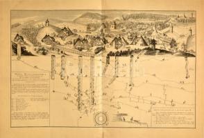
1726 Selmecbánya latképe és bányáinak, tárnáinak térképe Mappa metallographica celebris fodinae Semnitziensis in Hungaria superiori, a qua effoditur argentum auro mixtum, quae habenda est pro sectione montis, in cujus visceribus inspiciuntur subsequentia / Selmecbánya latképe és bányáinak, tárnáinak térképe. Marsigli, Luigi Ferdinando (1658-1730): Danubius Pannonico-mysicus : observationibus geographicis, astronomicis, hydrographicis, historicis, physicis, perlustratus et in sex tomos digestus.Haga, 1726 c. munkájából. III. kötet 10. tábla. Nagyméretű rézmetszet. 70,5x45 cm. / Mines and view of Schemnitz (Banska Slavnica. Copper plate engraving. Az olasz Luigi Ferdinando Marsigli a török elleni felszabadító harcok idején hadmérnökként szolgált a császári seregben, 1691-ben az angol Royal Society tagjává választották, és Magyarország földrajzának tanulmányozására, adatgyűjtésre kérték fel. Hazánk térképeinek pontosítását segédjével, Johann Christoph Müllerrel közösen végezte el: Szép, tiszta metszet.
Basket cost in total: